Blog: Seen from space: Canadian highway to Arctic Ocean nears completion

A few days ago, The Washington Post ran a story about the Dalton Highway in Alaska. This packed gravel road courses north from Fairbanks up to Deadhorse on the Arctic Ocean, where the oil fields of the North Slope lie. The newspaper headline read, “This 414-mile road to the Arctic Ocean is one of the world’s most remote highways.”
That Alaskan highway will soon have some competition from its neighbor.
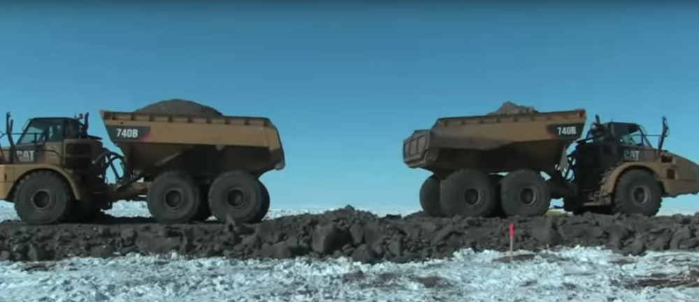
On April 7, two crews working in Canada’s Northwest Territories met in the middle and filled in the gravel to connect their respective sections. One part extends south from Tuktoyaktuk, and the other section extends north from Inuvik, the town of 3,463 where the Canadian highway system currently terminates.
The dumping of the gravel by two earthmovers to connect the two road sections could be called the Canadian Arctic’s “Golden Spike,” drawing a parallel with the ceremonial moment in 1869 when the Union and Central Pacific railroads were joined at Promontory Summit, Utah. The hammering of the Golden Spike into the tracks fused the United States of America together by rail from sea to shining sea.

The Inuvik-Tuktoyaktuk highway, which will be finished in 2017 if all goes according to plan, will connect Canada from sea to sea to sea – from the Pacific to the Arctic to the Atlantic. A permanent connection to the frozen ocean, which is currently only accessible by ice road in winter, may allow Canada to carry out oil and gas exploration in the resource-rich Beaufort Sea.
The road, which Inuvialuit-owned Northwind Industries is constructing, was originally budgeted at CAD $299 million. While the government has claimed that the expensive project will greatly benefit the 900-odd residents of Tuktoyaktuk by lowering their costs of living and improving transportation access, it may in fact disproportionately benefit the oil and gas companies that seek easier access to the North. Whereas The Globe and Mail in 2014 called the forthcoming highway “a new lifeline to the Arctic coast,” seen from another perspective, the road could prove to be a hangman’s noose if it succeeds in facilitating full-scale fossil fuel extraction in the Beaufort Sea.
The historic moment at kilometer 50 of the new highway was captured on video and set to triumphant music for the Government of the Northwest Territories.
What hasn’t yet been reported is that NASA’s Landsat satellite also passed over the highway on April 6, just one day before the final gravel was poured. The timing is quite fortunate since Landsat only passes over any given spot on Earth every 16 days. Even more serendipitously, the skies over the Northwest Territories were cloud-free that day, allowing the satellite a clear view of the black road cutting across the white snow below.
Here’s how the 137-kilometer long, two-lane Canadian highway, which is due to open in 2017, looks from 438 miles out in space. Some might call it a lifeline, while others might call it a scar on the tundra. And some might just simply see the road as concrete proof of mankind’s extension northward, whether foolhardy or awe-inspiring.

This post first appeared on Cryopolitics, an Arctic News and Analysis blog.


