Canada
By car
Introduction
Highway 93, south of Kootenay National Park, British Columbia.
(Parks Canada)Canada has the largest road network in the world with 900,000 kilometres of roads. That’s enough to make 22 trips around the world!
In any country, road infrastructure is crucial. But, in Canada, the second biggest country in the world, the road network is absolutely vital.
Trucks are the primary means of transporting goods between Canada and the United States.
Nearly 60% of the products we sell to the United States, and a third of those sold internationally, are transported along our roads loaded on hundreds of thousands of trucks.
There are approximately 750,000 trucks in Canada. More than 400,000 of them are used to ship commercial goods. In a country of 37 million people, about 300,000 of them are truck drivers, 1% of all employed men are truck drivers, making it one of the most important professions in Canada.
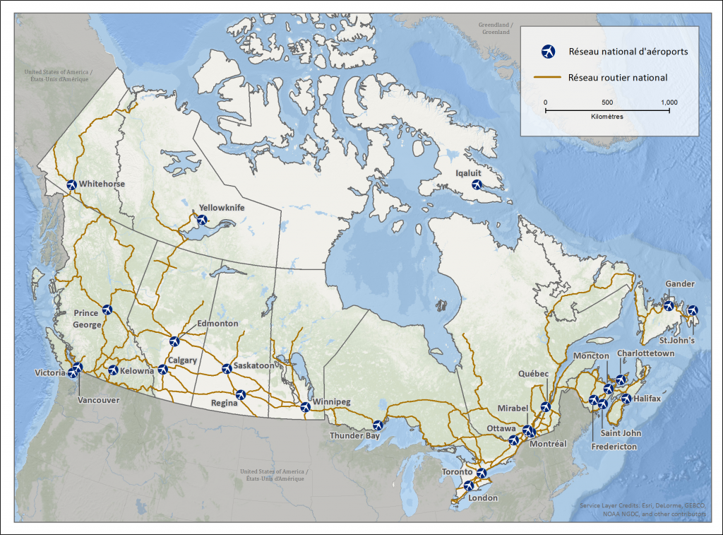
The National Road Network
In 1988, the federal government adopted the National Road Network (NRN) program. Since then, the roads forming this network are targeted for priority maintenance programs, such as winterizing or modernization projects.
By 2015, these critical roads totaling 38,075 kilometres, may look like a formidable figure but they represents only three per cent of all Canadian roads!
Thirty-seven per cent of cars and approximately 40 per cent of all trucks travel daily along this 38,000- kilometre road-network.
Government of Canada
The longest road
When it comes to the busiest and most important roads in Canada, the famous Trans-Canada Highway tops the list.
It is often referred to as a ‘road’ and not a ‘highway’ because some sections have only two lanes, particularly in some forested areas and in sparsely populated areas such as northern Ontario.
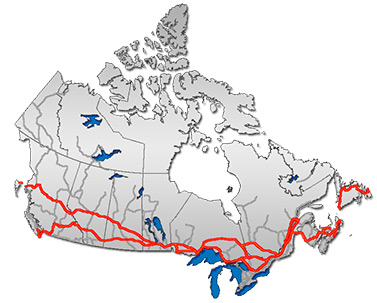
The Trans-Canada Highway network. In some parts of the country, this highway consists of two separate sections to connect most major cities, most of which are located in southern Canada
(Public Domain)Watch
Construction of the most expensive section of the Trans-Canada Highway: the Louis-Hippolyte-Lafontaine tunnel under the St. Lawrence River, south of Montreal (CBC Archives)
North America’s busiest Highway 401 near Toronto, Ontario.
Did you know?
- Three-quarters of Canada’s roads are in the eastern provinces of Ontario and Quebec.
- Half of Canada’s paved roads are also in Ontario and Quebec.
- Almost half of Canada’s unpaved roads are found in western Canada in the provinces of Alberta and Saskatchewan.
By the numbers:
The Trans-Canada Highway on the west coast of Canada, bordering the Pacific Ocean
(Stephen Edwards)52
The average number of kilometres travelled daily by a Canadian driver.
Every day, Canadians drive almost 25% farther than Europeans or Americans.
25,060,399
The total number of vehicles in Canada, a country with 37 million inhabitants.
There are around 68 vehicles per 100 persons in Canada. By comparison, there are 50 vehicles per 100 people in Europe.
43
The number of kilometres of road per person in Canada. This is the highest such ratio in the world.
In the United States, the ratio is 30 kilometres of road per person. Germany has eight kilometres of road per person and France has 16 kilometres of road per person.
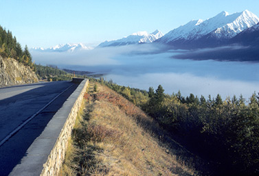
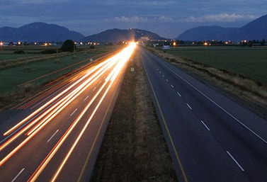
The Trans-Canada Highway
This section of the Trans-Canada Highway in British Columbia receives on average 3.7 metres of snow each winter.
(Adam Baker)The Trans-Canada Highway, which connects Canada’s ten provinces to one another, is the longest national highway in the world. Measuring 7,821 kilometres, the highway extends from the Pacific to the Atlantic Ocean.
In wooded or mountainous regions of Canada, the east-west artery is often the only route for hundreds of kilometres. The highway is the economic heart of Canada and is vital to tourism. The Trans-Canada Highway is the backbone of the National Highway System.
From highway to road
In some remote areas of the country, the Trans-Canada Highway consists of only two lanes. Near more populated areas like Toronto and Montreal, the highway consists of 12 to 16 lanes of traffic.
In 2000, the Canadian government considered having four lanes across the country. However, the project has remained on the back burner ever since. Several portions of this road, especially in northern Ontario, are not busy enough to justify the high costs of maintenance in winter.
Through the mountains
The construction of the Trans-Canada Highway was more difficult than expected.
Crossing the steep, snowy regions of the West, including the famous Canadian Rockies, engineers had to call in reinforcements. In British Columbia, construction was particularly difficult, especially between the villages of Golden and Revelstoke in British Columbia near Rogers Pass.
But going through this mountainous pass was absolutely necessary in order to build a road large enough to pass through the Canadian Rockies.
Work on this stretch of the Trans-Canada Highway began in 1956. In 1962, Canadian Prime Minister John Diefenbaker went to Rogers Pass for the official opening. But it wasn’t until 1971 that the entire road was completed from coast to coast.
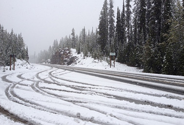
Winter driving
It’s not uncommon to see 15 metres of snow falling per year in some sections of the Trans-Canada Highway, especially in Rogers Pass.
This causes a serious avalanche risk. Tunnels had to be built through mountains in order to protect motorists.
Some stretches of road turn into battles between man and nature each winter. This is why Canada had to create the biggest avalanche prevention program in the world.
Summer driving
Summer driving in Canada is not without risk. Animals can cross roads without warning. Numerous collisions with wild animals take place between Yoho National Park and the town of Golden in the province of British Columbia.
Watch
Travelling the Trans-Canada Highway through the Rocky Mountains in British Columbia
A great story
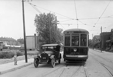
A car and a tramway on the corner of Queen Street and Bay Street in 1920. Today this is the heart of downtown Toronto.
(Archives, City of Toronto)The first highway in Canada
Canadians built their first highway in 1915. The 60-kilometre road was made of cement and wound its way through southern Ontario, the most populated region of Canada.
This highway links the economic capital, Toronto, to the industrial city of Hamilton.
Did you know?
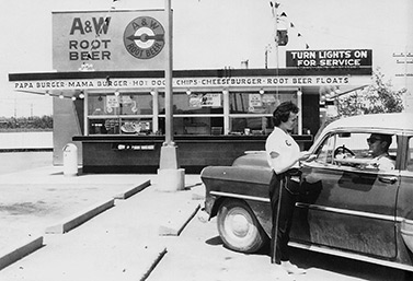
(CBC / jalopies.blogspot.ca)
The first hamburger stand on the highway
In 1956, fast-food giant A&W opened a restaurant in a rest area along a busy highway in Winnipeg, Manitoba.
It was the first burger chain to open to Canada.
By the numbers:

Toronto is the fifth largest city in North America in terms of size. Traffic is heavy on Highway 401.
(CBC News)– 401
- This is the number worn by the Trans-Canada Highway in southern Ontario.
- The 401 is the busiest highway in North America and as of 2015 it was also the busiest in the world.
- 420,000 vehicles travel its 800 km every day.
- Almost 900 kilometres long, it connects Canada’s two largest cities, Toronto and Montreal, in 5 hours.
Ice roads
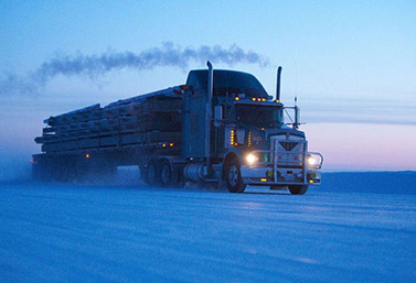
A truck drives on an ice road towards Yellowknife, Northwest Territories.
(CP PHOTO / History Channel)Every winter, a temporary road network extending over 1300 km is built on ice in northern Canada. These roads enable the flow of goods to the 100,000 people who live in Canada’s North. Many of these people live in one of the North’s 80 remote villages. Some communities are made up of only a few houses grouped around a trading post or government weather station
The construction and maintenance of a permanent road network to serve these sparse populations would be a monumental task. Not only because of the distances involved, but because of the many lakes and rivers located on the territory. Fortunately, these bodies of water freeze in the winter and become so solid that even trucks can drive on them
A vital artery
Northerners have been turning their lakes and rivers into highways made of ice since the 1930s. But the season for these ice highways is very short, only eight to ten weeks from early January to early March.
During these winter months, ice roads are used to transport every bottle of Coca-Cola and box of pasta that some communities consume in a year.
Ice roads cut the cost of transporting goods, which are exorbitantly expensive when transported by boat or plane. Without these ice roads, it would be impossible to transport objects too large or too heavy for air transport.
Ice roads and ice highways also exist in Finland, Russia and the United States. However, the longest highway, measuring 600 kilometres, is located in Canada.
NWT Ministry of Transportation
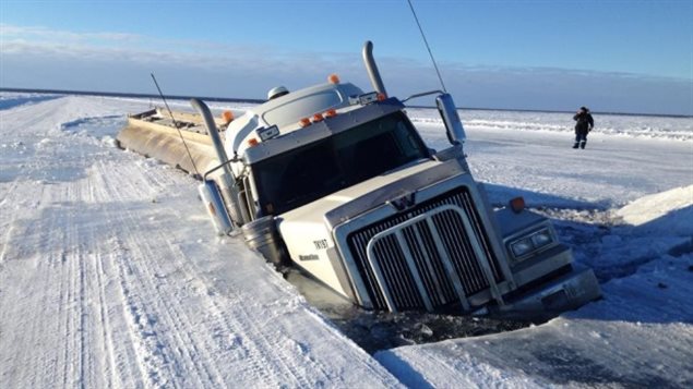
Driving on ice
Each year, Canadian truckers transport about 10,000 loads on Canada’s ice roads. Temperatures can reach -60 C.
The challenge for these truckers, nicknamed ‘Ice Road Truckers,’ is to roll their vehicles forward without any sudden maneuvers that could crack the frozen surface.
Truck speed is usually limited to 30 km/h, even on clear days. This allows drivers to detect cracks more easily and avoid them in time. Moreover, it prevents the trucks to producing pressure ridges in the ice surface and damaging the road.
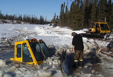
This tractor specializes in snow removal from ice roads. It lost control in northern Ontario in January 2013. The two men on board came very close to losing their lives.
(Kitchenuhmaykoosib Inninuwug)The future of underwater ice roads
Submarines supplying Canadians
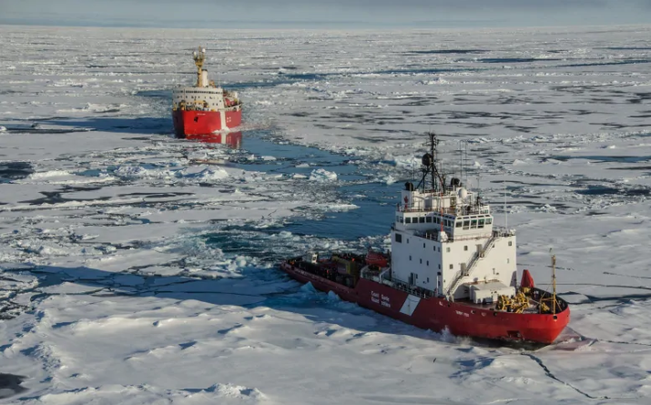
CCGS Terry Fox breaks the ice in front of CGGS Louis S. St-Laurent during a scientific mission mapping Canada’s Arctic continental shelf in 2015 (Gary Morgan/Canadian Coast Guard).
Global warming is threatening the existence of ice roads.
Periodically since 2011, many ice roads in the Far North could not support traffic until mid-January. Some were closed as early as the third week of February. As a result, there are plans in Canada’s Far North to transport goods by submarine in the future as winter strikes the region.
American submersibles have been travelling in the Far North since the 1950s, proving that it’s feasible to pass under the Arctic ice.
Giant submersible tank barges towed by atomic submarines, are just some of the images evoked by future underwater ‘ice roads.’ carrying oil from northern Canada to southern markets and Europe. In addition, Canada’s North is rich in mineral resources including reserves of gold and diamonds. These goods could also be transported by submarine.
Did you know?
A section of ice road in northern Canada. The colors of ice give important clues to its strength.
(Ian Mackenzie)To create ice roads, engineers must first remove snow from the waterways.
Then, over the newly exposed ice, they throw a mixture of snow and water taken from a lake. The mixture sets evenly and quickly in the intense cold.
Throughout the winter, trucks armed with pumps spray the ice roads with water to seal cracks due to changes in atmospheric pressure and temperature.
The ideal temperature to create or repair an ice road is -20 C. To check the thickness of the ice and make sure it is safe, there’s no need to drill holes every kilometre. Today, engineers use a small sonar, similar to those used by fishermen to detect fish. A trained eye can also gauge the thickness of the ice.
To be safe, ice must be blue or black. If it has ‘white eyes’ at the surface be very careful!
Read
The ice roads of Northern Canada are disappearing – CBC
View
Take a short drive with Eye on the Arctic producer Levon Sevunts as he ventures on the 400-kilometer-long ice road between the Tibbit and Contwoyto lakes to see what it’s like to be an ice road trucker.
Watch
The Ice Road in Tuktoyaktuk, Northwest Territories – CBC News
Avalanches
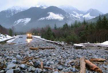
A spring landslide forced the closure of Highway 19, about 40 kilometres north of Sayward River Bridge, Vancouver Island.
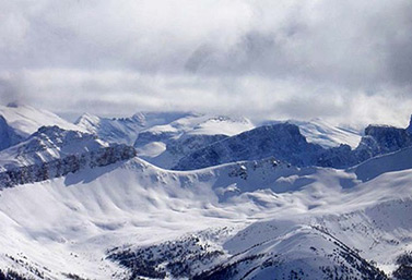
(Drive BC)Snow can overrun vehicles attempting to cross the Canadian Rockies in the West. The avalanche risk is very high.
The section of the Trans-Canada Highway crossing the Glacier National Park in the Rockies is well known for its record snowfall. Protecting motorists and truckers who take this route in the winter is done at great expense.
It’s herculean task. Concrete tunnels are built along the highway so drivers are protected from oncoming avalanches. But these structures prevent travellers from seeing some of the most striking views of the Canadian Rockies.
The avalanche prevention program
The program was created in this mountainous region of Canada, prone to some of biggest avalanches in the world.
3.5 to 4.5 metres of snow accumulate here each winter, especially in Rogers Pass. When the mountains can no longer support the snow’s weight, avalanches occur.
Parks Canada and the Canadian army team-up day and night and crisscross the area of the Trans-Canadian Highway adjoining Rogers Pass. Over the years, they identified 140 high-risk avalanche areas.
The military regularly monitors avalanche risk and evaluates whether explosives need to be used. For the past 50 years, the Canadian army has dropped explosive charges on the mountains from helicopters during avalanche season. It also uses guns fired from the ground.
By the numbers: 18
There are 18 avalanche control stations along Rogers Pass and the highway, a distance of 18 km.
Artillery can reach any of the 271 locations with a recognized avalanche risk from these locations.
At each station, the highway must be closed and snow removed. Typically, the army performs a dozen missions and shoots about 500 rounds in January.
Every time the army shoots at a snow peak or crest, the highway below must be closed.
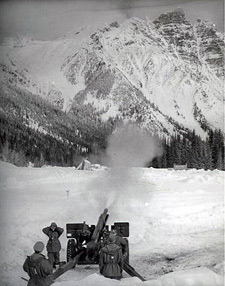
- The military trigger an avalanche along the Trans-Canada Highway in the 1960s.
(Parks Canada)
Did you know?
The Rocky Mountains in western Canada. Each year, an average of 14 Canadians are victims of an avalanche.
(Adrian Scottow)In Canada, avalanches are classified on a scale of one to five.
- A size one avalanche is relatively harmless to humans.
- A size two avalanche may bury, injure or kill a person.
- A size three avalanche can demolish a building, a small car, damage a truck and break trees.
- A size four avalanche can destroy a railway car, a large truck, a building or four hectares of forest.
- A size five avalanche can destroy 40 hectares of forest or a village.
Read
Canadian avalanche specialists, Government of Canada
As avalanche risk increases, government funds prevention – RCI
View
Avalanche! – CBC Digital Archives
Watch
Avalanche prevention in the Canadian Rockies (in French)
Drive the Trans-Canada Highway near an avalanche area
The history of Canada’s roads
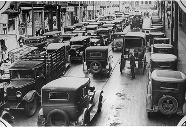
Traffic in Canada.
(Library and Archives Canada)The development of Canada was based first on river transport and then along its roads.
The first Canadian roads were the rivers and lakes used by indigenous people. They travelled by canoe in summer or on foot in winter. This network was so well-established that European settlers and the military followed suit.
For many years, the canoe was the only mode of transportation in Canada. In the seventeenth century, European settlers ventured into areas only accessible by water.
The considered the forests off-limits in winter because of the snow, and in the summer because they were afraid of aboriginal groups living in the area.
For a long time, Canada had short narrow paths connecting Canada’s villages instead of roads. Compared with Europe, Canada’s road network developed late.
The first roads
Canada’s first real roads were built with the help of a compulsory labour program. The program obligated settlers to maintain the roads near their properties.
Settlers had to work between three and 12 days a year to build and maintain municipal roads. The system of ‘compulsory labor’ was eventually replaced by an obligation to pay an annual fee to the city or locality.
Important dates
In 1606, the first official road was built in Canada. The 16-kilometre road was built near the town of Port Royal, Nova Scotia and was used for military purposes.
In 1734, a road called the Chemin du Roy connected Montreal and Quebec City, the two largest cities in Canada at the time. After completion, it took four days to make the 267-kilometre journey.
Toll roads and horse-drawn carriages
The need for better road infrastructure increased in the early nineteenth century.
But construction costs exceeded the ability of municipalities to pay so toll roads were established.
This was the era of the famous horse-drawn carriages of the early nineteenth century.
The carriages and toll roads give birth to trust companies. Some of these companies had significant stretches of road. Others companies were small enterprises.
The era of horse-drawn carriages ended with the arrival of the railway in Canada in the second half of the nineteenth century.
The rail network extended rapidly until the early twentieth century and Canadians gradually stopped using small regional road networks for their travels. These roads gradually deteriorated. Road construction was practically abandoned until the rise of the automobile in the early twentieth century.
Did you know?
Scene of a minor collision in Sainte-Thérèse, north of Montreal in November 2012. The accident involved a tractor-trailer and a school bus.
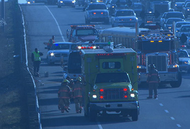
(Radio-Canada)Road accidents in Canada
In Canada, nearly 2,000 people die on the road and some 165,000 are injured (10,000 of them seriously) each year. In 2016, the number of road deaths in Canada reached 1,898 for a population of almost 37 million people. That’s just under 5.2 deaths per 100,000 inhabitants. France (7.5), and Germany (6) are doing worse than us, as are the United States (14).
Driving awareness campaigns, better roads and a better attitude are among the factors that explain the declining number of accidents in Canada.
The official goal of Transport Canada is to make Canada the safest country in the world in terms of automobile transportation.
Watch
Driving in Canada’s snowstorms
Driving in Toronto, Canada’s largest city
The great story
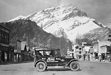
The Ford Model T and Dr. Perry E. Doolittle in downtown Banff, Alberta in 1925.
(Image – CAA)Crossing Canada by car has long been an adventure that took several weeks.
In 1925, no roads allowed a driver to cross the country from east to west. There were only roads located here and there, often unconnected. Only the railway was truly transcanadian.
Perry Doolittle, a Toronto physician, wanted to promote the idea of a national road. So he embarked on a cross-Canada trip in a specially adapted Ford Model T. Doolittle and his copilot were more resourceful and successful than expected. When they arrived in a cul-de-sac, they would replace their wheels with rail axles so they could drive on the train tracks.
It’s by rolling on rails that these two Canadians became the first to successfully cross Canada by car.
By the numbers:
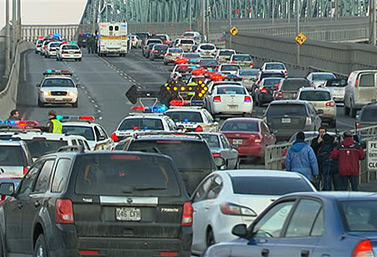
Motorists from Montreal waiting to cross a bridge spanning the St. Lawrence River.
(Radio-Canada)– 2131 –
Only 2131 cars were registered in Canada in 1907.
– 50 000 –
The number of vehicles on the road in Canada in 1914, on the eve of the First World War.
– 25 million –
The number of motor vehicles in Canada today, a country with a population of 37 million people. It’s one of the highest car-to-people ratios in the world.
The number of vehicles has almost doubled in the country since the 1970s.
Invented by canadians!
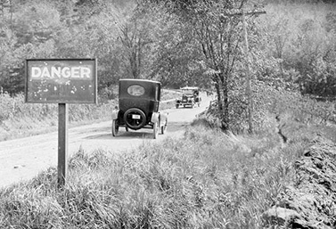
Sign indicating road danger in Winona, Ontario, May 21, 1922
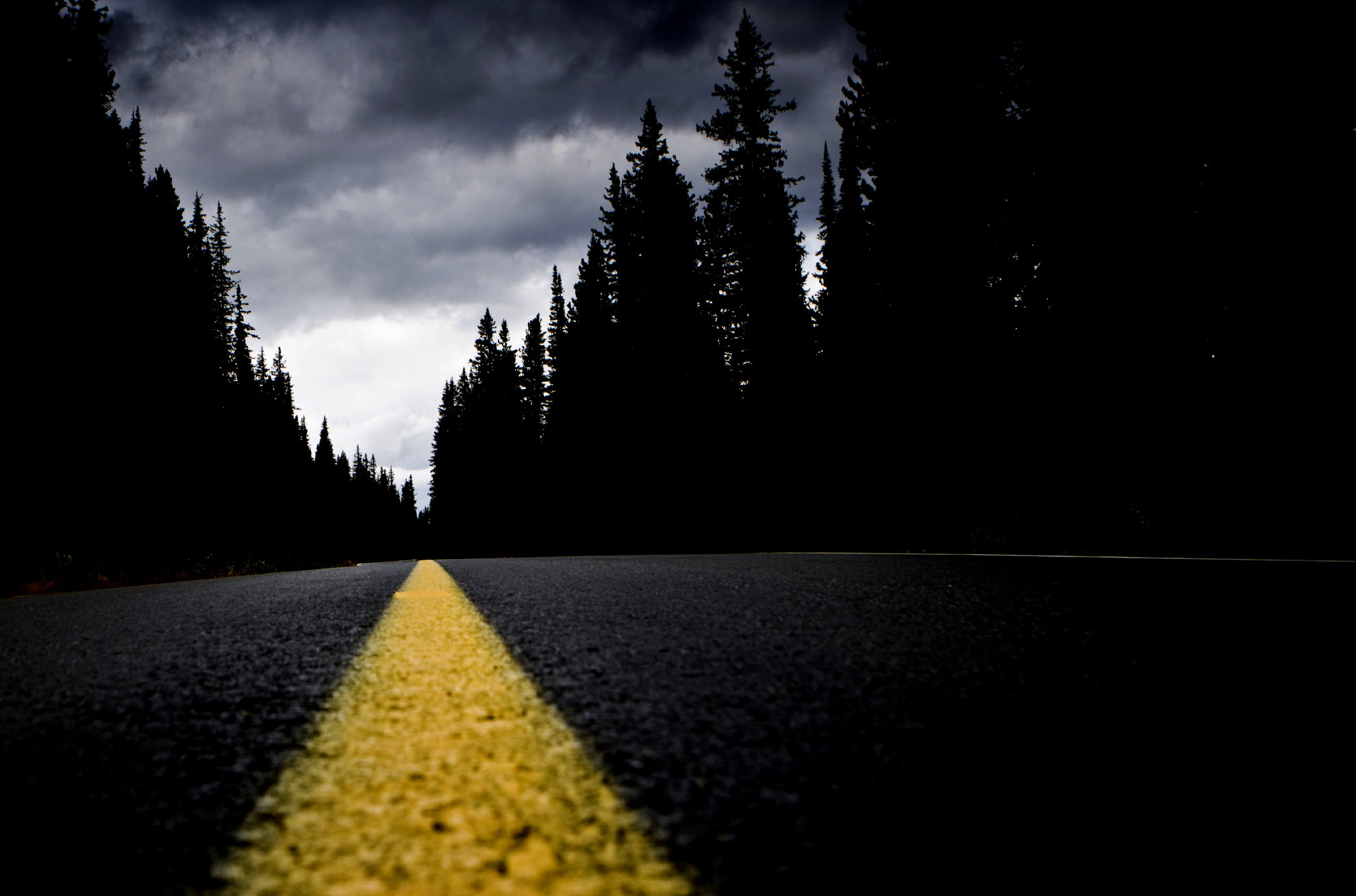
(Library and Archives Canada)The yellow and white lines drawn on roads are a Canadian invention.
Thanks to them, motorists around the world know whether they’re on the right direction or wrong side of the road. Imagine the confusion and accidents that would occur if there were no lines on the road!
And yet, these lines appeared more than 30 years after cars. Incredible but true: there were no lines on the road before 1930. For years, drivers could only warn vehicles that they were coming around a curve using horns, and sometimes waving bells.
In 1930, John D. Millar, an engineer of the Ministry of Transportation of Ontario, decided to paint lines on a small stretch of highway located on the border of Quebec and Ontario.
- Accidents fell dramatically after their introduction.
- The news of the invention spreads rapidly.
- In 1933, white lines were the norm throughout North America.
- In 1940, the whole world (almost) adopted the system.
Over time, the system was improved: dotted lines were added for passing and double lines were added around curves.
Photo Album