Study says ‘bottom-up’ permafrost thaw led to two major N.W.T. landslides
Wildfires decades before destabilized ground, setting off chain of events that caused the landslides
New research investigated two massive landslides in the Mackenzie River basin that happened nearly a decade ago.
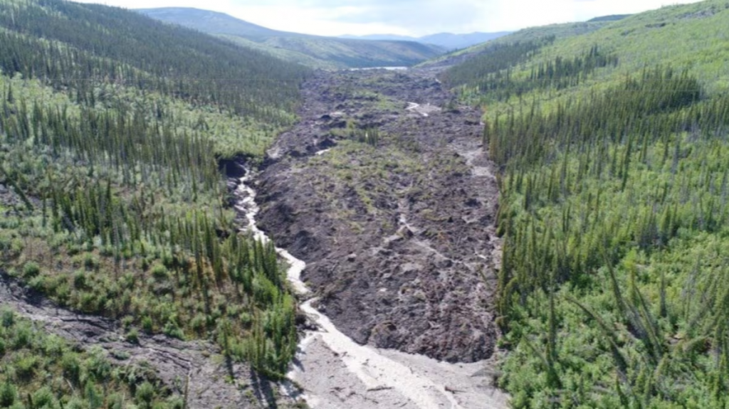
The two landslides in question happened on the Johnson River and the Redstone River, recorded in 2017 and 2018, respectively. Researchers call them “permafrost detachment slides”, as they determined their cause stands apart from other similar events related to permafrost thaw.
Joseph Young, a PhD student at the University of Alberta during the research, and lead author on the study published last month in Geophysical Research Letters, described the difference.
“Typically in permafrost regions, failure occurs from the top down,” Young said, describing how warming air temperatures and increased precipitation prompts permafrost to thaw, which can result in landslides happening over decades.
“These features get progressively larger as time goes on, and they keep thawing out the material and expanding.”
Young said permafrost detachment slides happen when permafrost fails about “20 metres down.”
“Instead of this progressive enlargement from the surface down, you have a very rapid and abrupt failure from the bottom up,” Young said.
He described these slides as large and quick.
“They can move the amount of material, which would take standard ways of permafrost failure a few decades to reach, in a matter of days in some cases.”
It’s estimated that the Redstone River landslide moved about 4.5 million cubic metres of ground into the river basin in August 2018.
The Johnson River slide showed signs of failure for some time before it happened in August 2017, and moved four times as much ground, about 18 million cubic metres — enough to fill about 7,200 Olympic swimming pools.
‘It looked like the land all of a sudden got stretch marks’
Eric McLeod saw the Johnson River slide from the air, and explained how he watched the landscape change in his flights over the area in the following years.
“I continued to fly in that area until about 2021. I was flying over it basically four times a year in all various seasons,” McLeod said.
He described flying over the area in May 2017, and already seeing a huge portion of land had slid into the river.
“The helicopter pilot had noticed that he had seen it before, and he had said it is now completely all the way down the hill and blocked the river, and it’s creating a lake,” McLeod said.
“It looked like the land all of a sudden got stretch marks; it wasn’t like some of the other ones that I’ve seen that look like they just melt away.”
McLeod said they landed the helicopter at the Johnson River slide shortly after it happened later that year. He compared the size of some of the pieces of displaced earth to the size of houses.
“One of them was about 20 feet thick.”
How wildfire in 1995 led to large-scale landslides
Young said wildfires set off the process that resulted in the slides.
“In 1995 this area burned quite severely,” he said.
Co-author Steve Kokelj, with the Northwest Territories Geological Survey, said the wildfires wiped out organic material, which had an impact on the top layer of permafrost right away.
“About 15 to 20 years after the fire, all of these larger disturbances start to occur within these old burn areas,” Kokelj said. “That’s about the time it takes for that to permeate 20 metres into the ground.”
“It’s the warming effect on permafrost in this scenario, the warming effect of fire compounding, [and], of course, the effects of a warming climate.”
For these particular phenomena, Young and Kokelj said there are signs before a permafrost detachment slide happens that can predict what’s coming.
“That’s kind of the silver lining,” Young said. “It doesn’t just happen overnight, it kind of happens in a more progressive manner over the course of about 20 years after a fire where you get a slow downslope movement of these slopes.”
Related stories from around the North:
Canada: Québec funds research to adapt Nunavik public housing to thawing permafrost, CBC News
Norway: Thawing permafrost melts ground under homes and around Global Seed Vault in Svalbard, The Independent Barents Observer
Finland: Experts urge policy overhaul to address climate tipping point risks, Eye on the Arctic
Russia: Melting permafrost may release industrial pollutants at Arctic sites: study, Eye on the Arctic
United States: 30–50% of critical northern infrastructure could be at high risk by 2050 due to warming, says study, Eye on the Arctic