Yukon sets up website to track Whitehorse problem bears
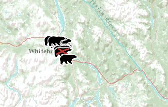 Map shows locations of bear sightings and what likely attracted them
Environment Yukon has launched a new web-based map to show where conflicts have happened with bears in Whitehorse.
The map is updated as information comes in, and bear sightings stay up on the map for one week to keep it current.
“Part of the educational feature of this is that people will be able to go and see where there are conflicts in their neighbourhoods and hopefully be able to take the steps that need to be taken to look in their own backyards and reduce any attractants that might be there,” said Ken Knutson, a Yukon government conservation officer.
The map shows where the bear was spotted and whether it was euthanized or not. Some of the locations on the map also have photographs showing things which likely drew the bear to the site, such as a compost or garbage bin, and even a dirty barbecue.
Knutson said conservation officers have dealt with 30 conflict bears in Whitehorse so far. There was a particularly high volume of calls about problem bears in the city this weekend, as well.
To see the map, you can visit the Environment Yukon web page.
For more stories from CBC News, click here