
Looming threat in Juneau, Alaska – Mendenhall Glacier could let loose water surge
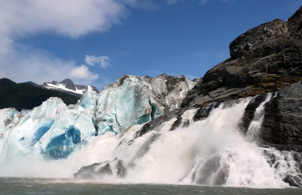
(Aron Stubbins / Skidaway Institute of Oceanograph / Alaska Dispatch)
JUNEAU — Alaska’s capital city, once thought to be almost immune from the effects of global warming due to a geologic quirk, now finds itself threatened by a different global warming oddity.
Juneau’s Mendenhall Glacier hangs over the town’s largest residential area, Mendenhall Valley. Like almost every glacier that flows out of the massive Juneau Ice Field, it’s been steadily retreating for decades.
But concerns are mounting that the shrinking glacier may trigger what are known as “glacial-outburst” floods, where water trapped behind glacial ice suddenly springs free and flows downhill.
The first outburst flood caught Juneau unaware.
“The first one in 2011, that one was a total surprise. Last year we were sort of ready for it, but we didn’t have real-time monitoring,” said Jason Amundson, a glaciologist at the University of Alaska-Southeast in Juneau.
During that flood an estimated 3.8 billion gallons were released from a basin behind an ice dam, but the water came in mid-summer, following an extended dry spell, and the Mendenhall River was at a very low flow. Still, houses along the river and near Mendenhall Lake experienced minor flooding. A campground and some roads were closed.
“That was pretty much the highest flow ever recorded on the Mendenhall River during that 2011 outburst flood, and certainly if it had happened at a higher base level it could have been ever higher,” said Eran Hood, another UAS scientist studying the glacier.
‘Worst-case scenario’
The possibility of worse flooding is troubling, said Tom Mattice, emergency program manager with the City and Borough of Juneau.
“The potential exists, depending on how much water is in the river on a given day, and how much water is in the basin on a given day, to potentially have a worst-case scenario,” Mattice said.
Unfortunately, no one can say with any assurance just what a worst-case scenario might look like.
A similar, but smaller, outburst flood happened again in 2012, and more floods are expected, say Amundson and Hood. “It’s very difficult to take our two years of data and make a worst-case prediction,” Hood said.
Another Juneau Ice Field glacier, the Tulsequah Glacier, has been releasing outburst floods for decades, though those floods happen in remote Canadian wilderness and present little danger. Studies there that show a wide range of flood volumes make Hood and Amundson reluctant to make predictions about the Mendenhall floods.
Hoping to get more data, and possibly provide advance warning of future floods for Juneau residents, the city, university and National Weather Service have this year established real-time monitoring of the Mendenhall Glacier’s flood potential.
Glacial floods rare near populated areas
Outburst floods have been studied for years in places such as Iceland, where they’re known as “jökulhlaups.” They’re a regular occurrence near the tiny Southeast Alaska community of Hyder, and at one time were an annual occurrence on the Knik Glacier, before it retreated to a point where they no longer occurred.
Elsewhere, it’s rare for them to be near a populated area.
“If it happens in the middle of nowhere, it’s no big deal. Unfortunately, the Mendenhall River is not in the middle of nowhere,” Mattice said.
The Mendenhall Glacier’s outburst floods come from the ominously named “Suicide Basin,” where a smaller glacier that once flowed all the way to the main Mendenhall Glacier retreated, leaving the basin nearly empty.
That empty basin fills every summer with rainwater and meltwater. Then, at some point, the pressure of water in the Suicide Basin is strong enough to lift the glacier and the water flows under it down to Mendenhall Lake, and then farther down to Mendenhall River.
“Once that flow starts, the moving water will erode away a tunnel in the ice, that tunnel will get larger and larger, and the drainage will occur faster and faster,” Hood said.
Little is known about what happens deep under the glacier, and the route the water finds down to Mendenhall Lake, he said.
When the first outburst happened in 2011, there was initially a slight rise in the Mendenhall River that didn’t correspond to weather such as heat or rain that also can influence river flow. When the scientists looked back on it, they could see the early signs of the outburst.
In 2012, another unexplained rise in Mendenhall River flows happened as the outburst was about to release, but the scientists had no idea how much water Suicide Basin held and how big the floods would be.
They had been able to place data-logging equipment in the basin, but were not able to retrieve it until after the flood had crested. That year’s outburst was smaller than 2011 and did no damage.
Water building in Suicide Basin
This year a satellite-linked water pressure sensor has been placed in Suicide Basin and is providing up-to-the minute readings as the basin begins to fill.
“We’ll not only see the water building in Suicide Basin, but we’ll also see the water draining out of Suicide Basin,” Mattice said. “We’re hoping this will add quite a bit of time to the warnings.”
Glacier tour companies NorthStar Trekking and Temsco Helicopters have helped out by ferrying scientists and equipment to the glacier, the team said.
“By having a real-time monitor it gives us a heads-up,” Amundson said. “It’s one thing to know that a flood is starting, but you also want to know how much water is going to come down. What’s it going to peak at?”
Hood said the new monitoring will help provide warnings, as they try to determine just how big future years outburst floods could be. As the Mendenhall Glacier thins and its weight diminishes, its ability to hold back large volumes of water may diminish too, Hood said.
On the other hand, as the remaining ice in Suicide Basin melts out, that basin may wind up being able to hold even more lwater. “We don’t know how much water it holds, and it changes from year to year as the amount of ice in the basin changes from year to year as well,” Hood said.
Melting ice flowing into into the oceans is causing sea levels to rise around the world, but even though most of Juneau lives close to sea level, it’s not been a problem locally. That’s because as the glaciers thin and retreat, their reduced weight is causing the ground itself to rise.
That’s called “isostatic rebound” and city officials say it has exceeded the rate of sea level rise for years.
The threat of glacier outburst floods is a risk that Mattice wasn’t aware of when he took the job five years ago, and its something that few of his fellow emergency managers around the nation have to deal with.
“But then again, I don’t have tornadoes or hurricanes either,” he said.
Contact Pat Forgey at pat(at)alaskadispatch.com
Nicely explained. This is a cost effective monitoring program, the allows forecasting of a potential hazard. The changes in the glacier of the Juneau Icefield from Aug. 17 1984 to June 21 2013 illustrates the issues.
http://glacierchange.wordpress.com/2013/07/01/juneau-icefield-glacier-terminus-change-from-landsat-5-1984-to-landsat-8-2013/