North on pace for hottest summer ever recorded; strong, gusting winds expected in southern N.W.T.
Several places in the North are on track to break records for the hottest summer ever recorded.
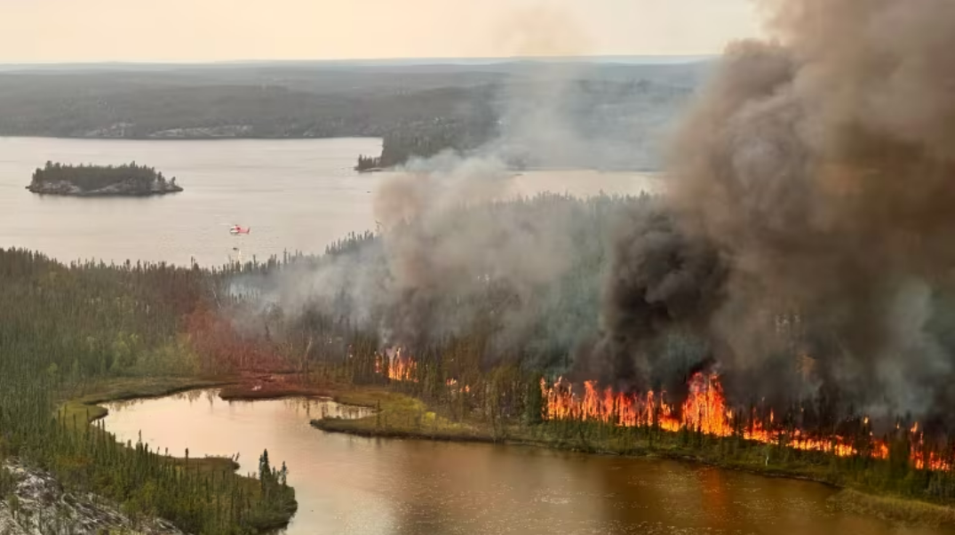
Experts expected extreme weather this year due to an El Niño event, and that has certainly borne out in the Northwest Territories with an unprecedented wildfire season.
Earlier this week, officials in Fort Smith, N.W.T., said they’d never seen drought levels so high.
Those hot, dry conditions are expected to last into the weekend, posing a challenge to firefighting efforts in the southern N.W.T.
“It’s not just the N.W.T. experiencing it, that’s northern Alberta, northeastern B.C., and parts of Yukon as well,” said Sara Hoffman, a meteorologist with Environment and Climate Change Canada.
“There’s a large mass of well-above normal temperatures for this time of year stagnantly sitting over the area, bringing temperatures anywhere from about eight to 15 C above normal for this time of year.”
Hoffman said a low pressure system is expected in the area Friday. Usually those systems would also bring rain.
“At this point in time, it looks like rain will stick more to the North Slave region, rather than over southern Great Slave Lake region,” said Hoffman.
She added that only between two and 10 millimetres of rain is expected.
“Still not what they would call a season-ender,” she said.
Fire officials have previously said that about 60 millimetres of rain in a 10-day period would be necessary to return to normal moisture levels in the region.
The low pressure system will likely bring strong, gusting winds to the South Slave region, and once it passes, temperatures should drop closer to normal levels for this time of year.
Friday’s forecast shows steady winds blowing southwest about 20 kilometres per hour, gusting up to 40 kilometres per hour near Fort Smith.
In Hay River, N.W.T., consistent 20-kilometre-per-hour winds blowing southwest are forecasted for Friday morning, gusting up to 50 kilometres per hour. In the afternoon, winds are forecasted to shift, blowing west at 40 kilometres per hour and gusting up to 60 kilometres per hour.
Firefighters are already preparing for a challenging couple of days.
“Our efforts have been on bolstering the defences that we’ve put in place over these past few weeks, and being ready to defend this place should the time come,” said Mike Westwick, fire information officer with the N.W.T. government,.
Yellowknife has also paused its return of most essential workers in anticipation of highway closures due to the strong winds.
“We urge everybody to follow the direction: do not travel Highway 1, between Friday and Sunday, watch for communication about when it’s safe to do so,” said Westwick.
Written by Francis Tessier-Burns with files from Hilary Bird
Related stories from around the North:
Canada: Yellowknife re-entry paused as winds expected to ‘accelerate’ fires near highway, CBC News
Norway: Smoke from Canadian wildfires forecast to reach Norway, The Associated Press
Russia: New NOAA report finds vast Siberian wildfires linked to Arctic warming, The Associated Press
United States: Wildfires in Anchorage? Climate change sparks disaster fears, The Associated Press