Nunavut, Canada breaks 47 daily temperature records in 1st 6 days of October
‘We are expecting a warmer than normal fall for the territory,’ says meteorologist Justin Shelley
So far, October is off to a warm start for parts of Nunavut — so warm in fact, that it’s breaking multiple daily records.
Justin Shelley, a meteorologist with Environment and Climate Change Canada, says an upper ridge of high pressure sitting right over Baffin Island is to blame. It’s drawing up warmer than normal air into the territory.
“For the most part, the last seven to 10 days, we’ve seen temperatures anywhere from two to 10 degrees above normal for this time of year,” Shelley said.
The warm air has mostly been centred over the Kitikmeot and Kivalliq regions, and up toward Resolute and Eureka as well, he said.
For instance, in Iqaluit, the normal for this time of year is about -1C, Shelley said. But in the past week, temperatures have been in the four to seven degree range.
“Even up in Resolute, it’s even more pronounced, where the normal maximum temperature this time of year is -10 C [but] we’ve seen temperatures the past week is zero or 1 C,” Shelley said.
“It’s definitely an anomalous period. And much warmer than normal for this time of year.”
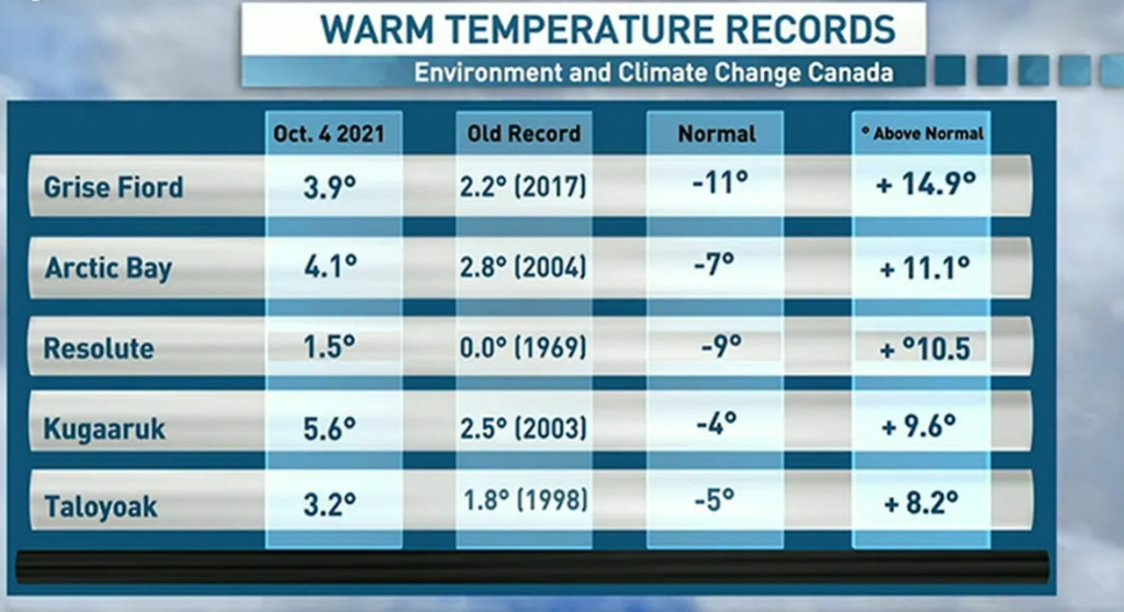
So far, there have been 47 daily records broken in Nunavut within the first six days of October, he said.
“Based on the outlooks for the month, and for the fall season, we are expecting a warmer than normal fall for the territory,” he said. “The signal is relatively strong.”
Shelley explained that upper ridges, like the one sitting over northern Nunavut now, “sort of just happen with the natural flow of the upper atmosphere.”
“Generally speaking, they don’t necessarily sit in place as long as they have over the region,” he said.
“But, we have had some more active storm tracks farther west, which inherently pulls up the ridge east of there and the warmer air gets pulled farther north, which we’ve seen in the past week.”
While he said individual weather events like this specific range can’t be directly attributed to climate change, pattern shifts — like having more extreme hot and cold spells — can be.
“That would be something we would expect moving forward in time,” Shelley said.
Related stories from around the North:
Canada: 2020 shaping up to be among warmest years on record says WMO, Eye on the Arctic
Greenland: Rise in sea level from ice melt in Greenland and Antarctica match worst-case scenario: study, CBC News
Russia: Russia’s Arctic coast warmest since records started says weather service, The Independent Barents Observer
Sweden: Reducing emissions could create up to 3,000 new jobs in Arctic Sweden says mining group, Eye on the Arctic
United States: Indigenous wildfire knowledge to be key part of new Arctic Council project, Eye on the Arctic