Icelandic authorities give hazard warnings as fissures spread lava and smoke
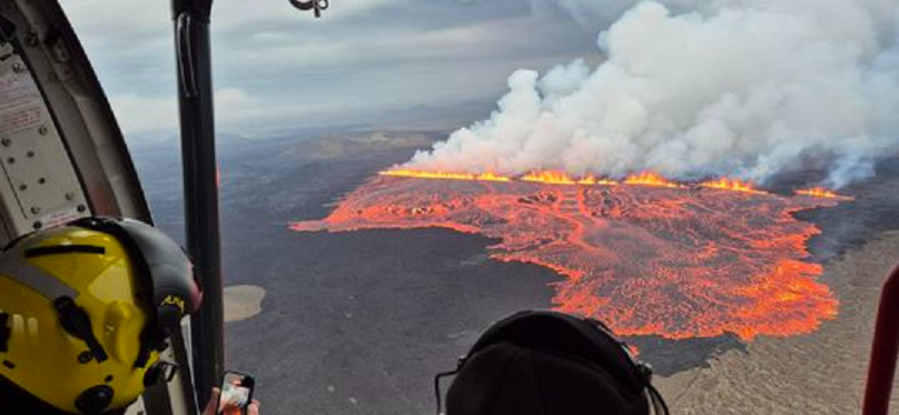
Iceland’s volcanic unrest intensified overnight as new fissures opened on the Reykjanes Peninsula, sending lava eastward and prompting fresh hazard warnings from officials.
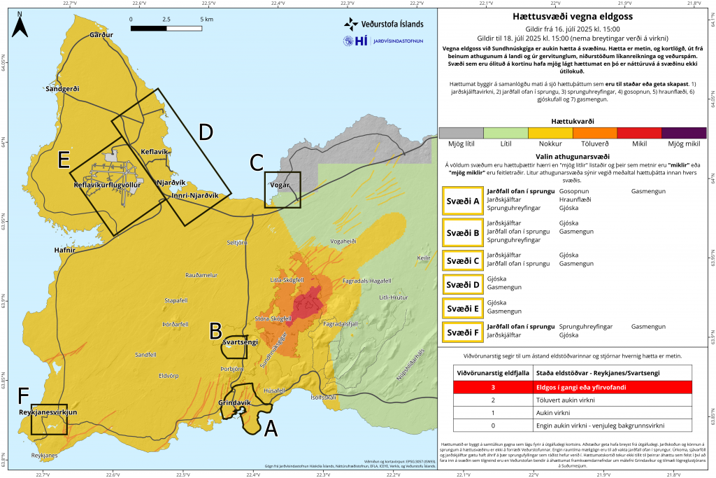
The eruption, centered along the Sundhnúksgígaröð crater, began just before midnight local time on Tuesday and has since expanded north. At last update, the main fissure measured approximately 2.4 km.
“Lava has flowed north and northeast from the source, spreading widely across Kálffellsheiði and toward Svartsengi,” the Icelandic Met office said in an update on Wednesday.
A smaller 500m fissure has also formed west of nearby Fagradalsfjall.
The office said although the intensity of the lava has reduced, it is still otherwise flowing steadily and covers more than 3.2 sq km.
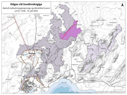
Most of the lava is pooling east of the fissure, filling low-lying areas across Kálffellsheiði. While no critical infrastructure is currently threatened, the met office warns that visibility in some directions remains poor.
Alert level will remain at highest level
Seismic activity had reduced to a few minor quakes per hour by afternoon on Wednesday, after surging in the lead-up to the eruption, the met office said.
The volcanic alert level remains at its highest, level 3.
Air quality a growing concern
High levels of sulfur dioxide pollution were measured over Reykjanesbær on Wednesday morning, with authorities warning of the potential health hazards.
“Residents are advised to stay indoors, keep windows closed, and turn off ventilation systems,” the met office said. “It is best to breathe through the nose.”
Drifting volcanic fibers known as “witch’s hair”—fine, sharp glass threads that form when lava drops cool and stretch—have been reported near the eruption zone. Authorities warned on Wednesday that the substance is able to travel long distances and can cause skin and eye irritation.
Wildfires ignited by the heat remain the biggest hazard to inhabited areas, emergency officials said.
A new hazard map released Wednesday marks multiple red zones for lava, gas, and ash threats.
The next official update is expected on Thursday morning, unless conditions change, Icelandic authorities said.
Write to Eilís Quinn at eilis.quinn(at)cbc.ca
Related stories from around the North:
Canada: N.W.T. Indigenous governments get $15M to deal with 2023 wildfires’ impact, CBC News
Finland: Flooding in Finland is getting worse, new climate report says, Yle News
Iceland: Resilience, recovery prioritized in Iceland report on Grindavik evacuation, Eye on the Arctic
Norway: Smoke from Canadian wildfires forecast to reach Norway, The Associated Press
Russia: New NOAA report finds vast Siberian wildfires linked to Arctic warming, The Associated Press
Sweden: High risk of wildfires in many parts of Sweden, including North, Radio Sweden
United States: Bursting ice dam in Alaska highlights risks of glacial flooding around the globe, The Associated Press