Commission issues recommended land use plan for Yukon’s vast Dawson region

Final plan will determine how roughly 10 per cent of Yukon’s land mass should be managed in future
A proposed land use plan for a vast area of central Yukon has been released, with detailed recommendations on what sort of development can happen in the region.
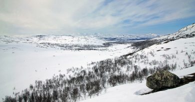
The Dawson Regional Planning Commission this week released its recommended plan, which has been years in the making and would lay the groundwork for how roughly 10 per cent of Yukon’s land mass should be managed in the future.
The plan is a requirement under Chapter 11 of the Tr’ondëk Hwëch’in Final Agreement.
The 480-page recommended plan is “grounded in co-management” between Tr’ondëk Hwëch’in and the Yukon government, it says.
“There is an expectation that in the implementation of this plan, the Tr’ondëk Hwëch’in and the Government of Yukon work together as equal and respectful partners to bring the vision and intention of this plan to life,” it reads.
The plan divides the 39,854-square-kilometre region into 22 landscape management units, each with its own specific recommendations about what sort of activity or development should be allowed there. Some are envisioned as conservation zones, with no industrial development or exploration allowed, while others could see future development such as mining operations or tourism.
The plan does not cover lands within the City of Dawson municipal boundaries or existing protected areas such as Tombstone Territorial Park.
When it comes to mining, the recommended plan would allow for placer mining — a major part of the local economy — in some areas and recommends “more consistent, streamlined, and transparent” processes for permitting and assessment. It also recommends working with placer miners and the local community “to create a plan for the future of placer mining in the region.”

The plan also says that quartz, or hard rock, mining is “not compatible in this region,” under the current regulatory system. It says territorial mining legislation is “outdated and insufficient to moderate the risks of quartz mining.”
There are currently no operating hard-rock mines within the Dawson region.
The plan also recommends a specific ban on heap-leach mining in the region, at least “under the current regulatory regime.” In 2024, a catastrophic heap leach failure at Victoria Gold’s Eagle mine near Mayo, Yukon, released toxic cyanide into the environment and prompted the immediate closure of the mine and an ongoing remediation effort.
The Yukon government has been working for years to overhaul its mining legislation, which is more than a century old.
The Dawson Planning Commission was established as an independent body in 2018, to craft a recommended land use plan for the region. The six-person commission released an early draft of the plan in 2022, and the Tr’ondëk Hwëch’in and Yukon government then provided input toward this final recommended plan.
The First Nation and the territorial government will now review the recommended plan and consult with affected communities. The two parties can then decide to accept, reject, or modify the document before it comes into effect.
Once a final plan is adopted, it will be the third such regional land use plan in the territory. A plan for the North Yukon region was adopted in 2009 and for the Peel Watershed region in 2019.
The Peel watershed plan had earlier been the focus of a years-long legal battle that ended when the Supreme Court of Canada found that the Yukon Government had ignored its treaty obligations when, in 2012, it rejected the Peel Planning Commission’s recommendations to protect about 80 per cent of the region from development, and instead presented its own plan that would have seen roughly 30 per cent of the region protected.
The court ordered the territorial government to restart the process and follow its obligations to meaningfully consult First Nations.
Related stories from around the North:
Canada: Inuit push for land protection with focus on social economy, Eye on the Arctic
Sweden: Land use rules getting hindering climate adaptation efforts in Swedish municipalities, Radio Sweden