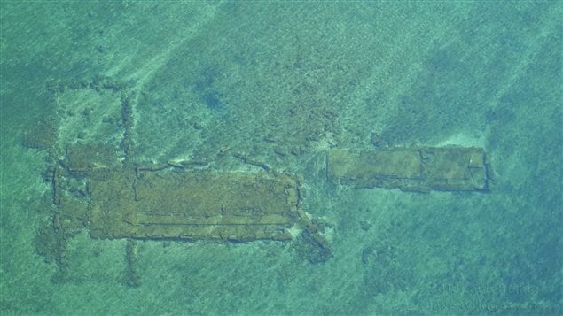
At first artist and aerial photographer Louis Helbig did not understand what he was seeing under the water surface as he flew over a lake that had been created as part of the lock/canal system of the St Lawrence Seaway which allows ocean-going ships access to Canada’s interior Great Lakes.
As he examined his photos, and researched what had been flooded by the water, he realized he was seeing the remnants of villages that had once been there, a highway, and even an historical battlefield.

Louis Helbig
He continued to photograph his aerial views, and talked to some of the thousands of villagers who had been displaced by what has been described as “one of the most challenging engineering feats in history” but was known to villagers as the “inundation”.
RCI’s Wojtek Gwiazda talked to Louis Helbig about his project “Sunken Villages” and the photos and videos that came out of it.
ListenMore information:
Louis Helbig “Sunken Villages” project – here
Louis Helbig webiste – www.louishelbig.com
Great Lakes St. Lawrence Seaway System website – www.greatlakes-seaway.com


For reasons beyond our control, and for an undetermined period of time, our comment section is now closed. However, our social networks remain open to your contributions.