New map shows what Bering land bridge looked like 18,000 years ago
Thousands of years ago, a stretch of land connected the continents of Asia and North America, in the place the Bering Strait now occupies.
The Bering land bridge was exposed at various times over an almost three million year period, when wide scale glaciation lowered sea levels by as much as 150 metres. The land bridge, or “Beringia,” which refers to the stretch of land between present day Siberia and Yukon Territory, has been home to woolly mammoths, steppe bison and humans.
Now, researchers have a better idea of what this region looked like and how our ancient relatives used the landscape.
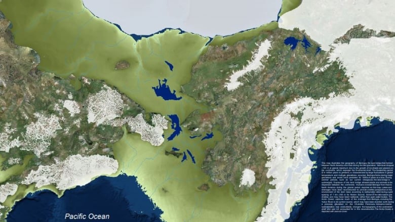
Jeff Bond, a geologist with Yukon Geological Survey in Whitehorse, has produced a map showing what Beringia looked like 18,000 years ago. At that time, much of the earth was glaciated, but Beringia remained predominantly ice-free due to its arid climate.

Bond compiled the map using sea floor data from the University of Alaska Fairbanks.
“The bathymetry data is the most current compilation available,” he said. “So yeah, it’s really — I think — the most detailed reconstruction of the land bridge that’s been put together to date.”
Bond said the data is accurate down to about one square kilometre in most places.
“It’s not super detailed, but we’re talking about a big landscape. It’s over 1,500 kilometres across.”
He said some areas have a 100 square metre resolution.
Human migration moved east across bridge
This is the first time the lakes and rivers of Beringia have been mapped. Bond said knowing more about the topography, including where the major drainages and highlands were, could tell us more about how humans used the landscape.
“I think these waterways would be very significant in terms of campsites, places which would have maybe impeded peoples’ migration or dispersion across the land bridge.”
Bond created the map to be used in an exhibit at the Beringia Centre, a museum in Whitehorse, northwest Canada.
Information on the centre’s website says the earliest evidence of people in the Arctic region dates to about 35,000 years ago in northern Siberia. It says people moved eastward and eventually across the land bridge. The first evidence of people in the Yukon dates back 15,000 years, although recent research says it might have been much earlier than that.
“It’s the story between 35,000 year ago and 15,000 years ago that is very intriguing,” said Julie Brigham-Grette, a geologist at the University of Massachusetts who helped Bond with the map.
“Where did they go, how did they live, why did they migrate?
“Maps like this really open your imagination to what these landscapes must have been like,” she said.
Brigham-Grette, who has been studying the land bridge for decades, helped Bond make sure the map is accurate, particularly with regards to the distribution of glaciers. Bond said the map shows the most current understanding of ice distribution along the border of Beringia.

Brigham-Grette said the lack of ice means people could have travelled along the coast.
“There are ideas that early humans were using boats … and maybe they were migrating along that coastline,” she explained.
“Some questions we may never have an answer for but [the map] … is just wonderful eye candy.”
Although Beringia is now covered by water, Bond says it might be possible for underwater archeologists to find out more about the people who lived there.
“Perhaps this map will give some marine archeologists some ideas about where to investigate the landscape for archeological sites,” he said.
The map is available online or through Yukon Geological Survey in Whitehorse.
Related stories from around the North:
Canada: Glacier melt in Arctic Canada exposes plants frozen under ice for 40,000 years, CBC News
Norway: Climate change is driving micro-algae blooms into High Arctic and may affect food chains, says study, Eye on the Arctic
Russia: Russian researchers applaud construction of Arctic station, The Independent Barents Observer
United States: New study predicts ‘radical re-shaping’ of Arctic landscape by 2100, CBC News