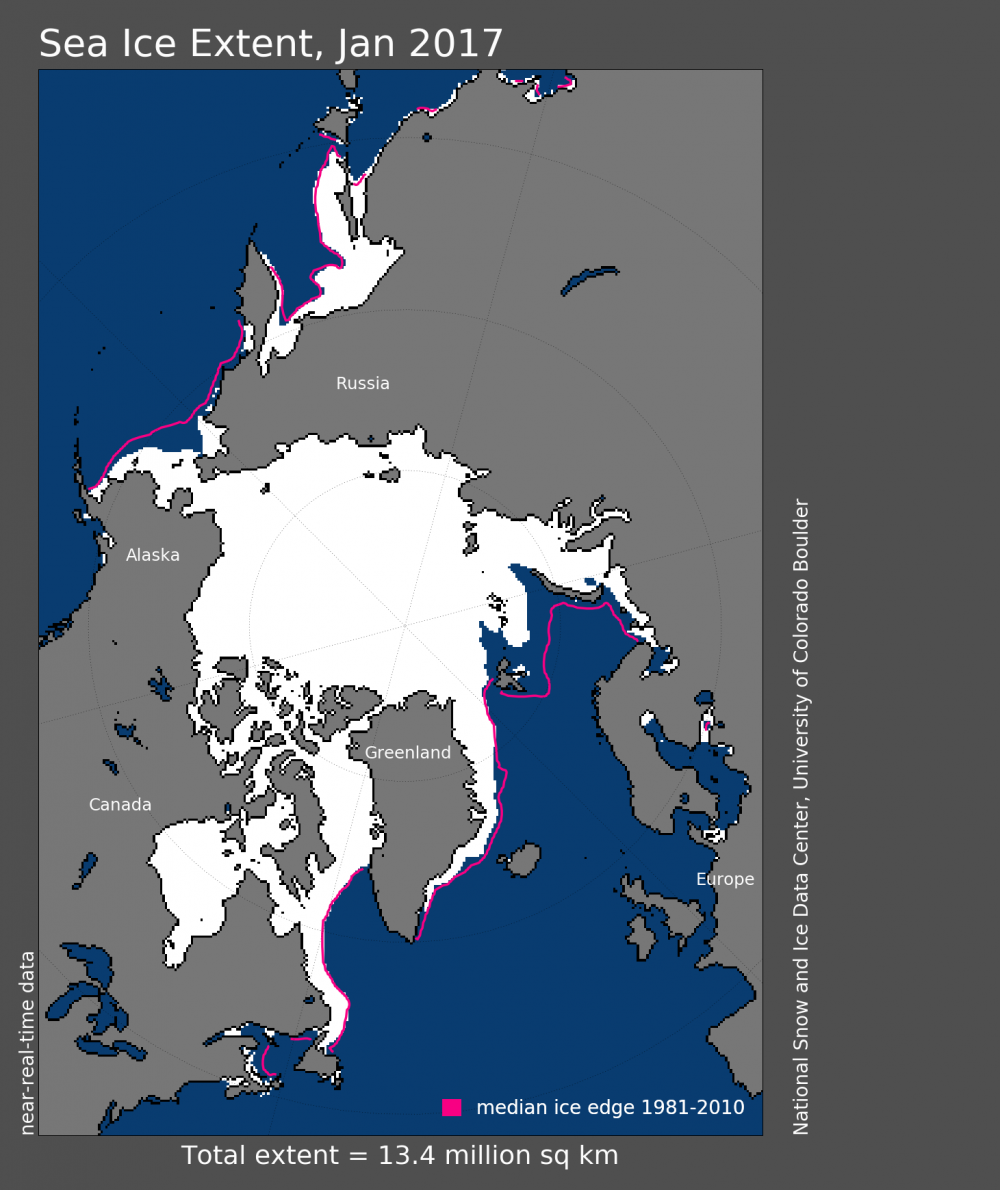
January sea ice extent at record low in Barents and Kara seas
Arctic alarm: Svalbard measured 3°C Friday morning. That is the same as in Paris 3,300 km further south.
January sea ice extent is the lowest in the 38-year satellite record according from National Snow & Data Center. Changes in the Barents- and Kara Seas are most dramatic with the ice edge still retreating in a month it should normally grow.
Through most of January the ice edge remained north of the Svalbard archipelago and even northwest of Russia’s Novaya Zemlya archipelago, the satellite analyses shows.
For Svalbard, weather this winter is upside-down with temperatures this week record high. On Wednesday, Longyearbyen airport at 78° North saw the thermometer peaked at 4°C for the third day in a row. That is 20°C warmer than normal for February in an area of the Arctic where the sun is still below the horizon.
Friday morning, Longyearbyen had 3°C, warmer than Paris, some 3,300 kilometers further south.
National Snow & Data Center explains the far north ice edge through most of January with the inflow of warm Atlantic water along the western part of the archipelago.
Warmer water than normal is, to put it gently, also a challenge for the northern part of the Kara Sea. Russia’s Hydrometeorological Service reports about average water temperatures up 2,5°C above normal, the Barents Observer reported earlier this week.
The Hydrometeorological Center does not exclude that the heat ultimately could result in almost ice-free Arctic waters already in the course of this decade.
Tipping point
What now happens in Arctic waters could be self-escalating. Oceans warm and ice thins and melts away, more solar heat is absorbed by the water, creating positive feedbacks that lead to further melting. That again gives less ice the next winter and self-escalation speeds up.
No other places on earth experience the effects of climate changes more visible than the Arctic.
National Snow & Data Centre’s study shows that January saw 260,000 square kilometers less January last year. The total of 13,38 million square kilometers of ice is 1,26 million square kilometers below the January 1981 to 2010 long-term average. First satellite measurements came in 1981.
Related stories from around the North:
Canada: Arctic sea ice hits new record winter low, Radio Canada International
Finland: Warm Easter predicted across Finland… even for Lapland, Yle News
Greenland: Arctic sea ice, Greenland and Europe’s weird weather, Blog by Irene Quaile, Deutsche Welle
Norway: A letter from Svalbard’s dwindling sea ice, Deutsche Welle’s Iceblogger
Russia: 2016, warmest year on record in Russian Arctic, The Independent Barents Observer
Sweden: Storm Helga weather warning for Sweden, Radio Sweden
United States: Ice extent still well below normal in Arctic, Alaska Dispatch News