
The federal government plans to file its submission on the outer limits of Canada’s continental shelf in the Arctic Ocean in early 2019 and Ottawa’s submission is expected to overlap with both Russian and Danish submissions, according to officials with Global Affairs Canada.
John Babcock, a Global Affairs spokesperson, said all of the scientific data needed to support Canada’s Arctic Ocean continental shelf submission has now been collected.
Government scientists and lawyers are pouring over the latest data collected in the summer of 2016 and are finalizing Canada’s submission, which is expected to be filed with the United Nations Commission on the Limits of the Continental Shelf in early 2019, Babcock said in an emailed statement.
“The continental shelves of the Arctic Ocean coastal states will overlap, but the full extent and location of these overlaps is not yet known,” Babcock said.
Canada, like the other Arctic Ocean coastal states, is committed to the orderly resolution of any such overlaps, he added.
Canada has collaborated extensively with the United States and Denmark in the collection of data in the Arctic Ocean, Babcock said.
In addition, all five Arctic Ocean coastal states meet annually to discuss technical and legal issues of interest relating to continental shelf delineation, he said.
‘A science-based process’
“This whole situation is a good news story in that Russia and the other Arctic Ocean countries, which are all NATO countries are continuing to respect the rule of law and the science-based process,” said Michael Byers, Canada Research Chair in Global Politics and International Law at the University of British Columbia.
Byers said it’s important to understand that the UN Commission on the Limits of the Continental Shelf does not define borders but merely rules on the scientific validity of geological data presented to it in support of claims to extend the outer limits of a coastal state’s continental shelf.
“It’s a purely scientific exercise,” said Byers, who has written two books on international disputes and law in the Arctic – International Law and the Arctic and Who Owns the Arctic?
Neither Russia nor Denmark with whom Canada’s claim will likely overlap have presented legal claims as to where the maritime boundary between the two countries should be drawn.
“When the submission goes in, it’s simply a submission of a scientific data and no one will be excited by that internationally because this is part of a science-based process,” Byers said. “I’m sure that there will be media headlines saying that Canada claims the North Pole and that will be wrong.”
Canada will be submitting data over an area north of Ellesmere Island that may go as far or even beyond the North Pole, but that is only scientific data, not a legal claim, Byers said.
“We’re not at the stage of anyone drawing maritime boundaries,” he said.
Arctic coastal states will have to negotiate their extended maritime boundaries only after the UN commission rules on the validity of their scientific data, a process that could easily take up to a decade, Byers said.
Extending outer limits of Canada’s continental shelf
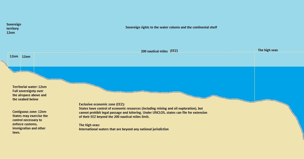 Under the United Nations Convention on the Law of the Sea (UNCLOS), which Canada ratified in 2003, all coastal states have a continental shelf extending 200 nautical miles (370 km) from coastal baselines.
That 200 nautical mile area of the continental shelf forms the coastal state’s Exclusive Economic Zone (EEZ), where it has special rights regarding the exploration and use of marine resources on and under the seabed.
Coastal states can also extend the outer limits of their claim by 150 nautical miles (278 km) beyond 200 nautical miles if the shelf is a natural prolongation of their landmass.
However, in certain circumstances a coastal state can claim even further than 350 nautical miles.
For example, if a coastal state can prove that a submarine elevation is part of its continental landmass and if that elevation extends beyond 350 nautical miles from its coastal baselines, that coastal state could delineate an outer limit of its continental shelf past 350 nautical miles.
Underwater ridges
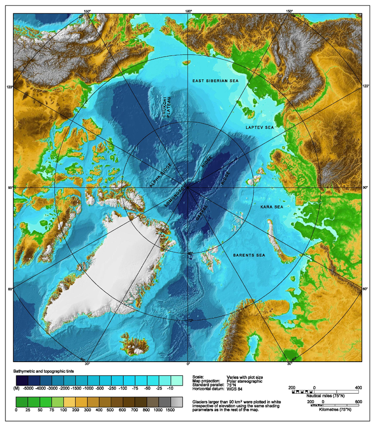
The International Bathymetric Chart of the Arctic Ocean (IBCAO)
Canadian scientists claim that Lomonosov and Alpha-Mendeleyev Ridges, underwater mountain ranges stretching under the Arctic Ocean from Canada to Russia, are submarine elevations, thus giving them the right to claim the seabed under the North Pole.
Both Russia and Denmark are making the exact same argument.
In 2001, Russia became the first Arctic coastal state to file its submission. In August of 2015, Moscow filed a partially revised submission.
In 2009, Norway became the first country to get its Arctic continental shelf submission in respect of areas in the Arctic Ocean, the Barents Sea and the Norwegian Sea approved by the UN commission.
Denmark submitted its claims to the northeastern and northern continental shelf zones of Greenland in November 2013 and in December 2014 respectively.
In 2013, Canada submitted a partial claim for the continental shelf in the Atlantic Ocean.
The United States has not yet ratified UNCLOS and cannot make a claim unless they do so.


For reasons beyond our control, and for an undetermined period of time, our comment section is now closed. However, our social networks remain open to your contributions.