Arctic Satellite image of the week: Russia discovers new island in its Arctic
In September 2013, two military helicopter pilots transporting equipment from Tiksi, a port city in northeast Russia, to the New Siberian Islands spotted a previously unknown island in the Laptev Sea.
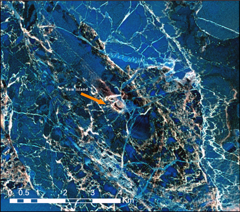
The discovery took place just a little ways south of the main shipping lanes used for the Northern Sea Route and has now been corroborated by geological surveying. The Russian-language version of Popular Mechanics notes that the small, low-lying island has been christened “Yaya,” or “Яя” in Russian. The rhyming name comes from the Russian word “Я,” which means “I”, for the pilot of each Mi-26 helicopter essentially shouted, “It was I who found it!” when they spotted the scrap of land.
The pilots happened to fly over the island (73°59′25″ N, 133°05′28 E) in September, when Arctic sea ice is at its lowest extent. September is the usually the first entire month to be open to shipping along the Northern Sea Route, too. I was unable to find cloud-free Landsat 8 satellite images taken over the location of the new island in September, or any of the other relatively ice-free months for that matter (July, August, and October), but I was able to find a cloud-free image taken on June 16, 2013, when the water was still frozen solid. Even despite all the thick sea ice surrounding the brown speck of land, it still manages to stick out.
Geographically speaking, the discovery reveals the extent to which the Arctic – especially the eastern Russian Arctic – still remains poorly mapped. It’s rare to hear of new islands – however small – being discovered elsewhere in the world unless they’re due to some recent volcanic activity.

New Siberian Islands Buildup?
Legally speaking, wile the island is small, its discovery does have certain implications under the United Nations Convention on the Law of the Sea (UNCLOS). All of the waters around Yaya Island already fall within Russian’s exclusive economic zone (EEZ). But Section II explains that territorial seas extend 12 nautical miles outward from a country’s coastline. Thus, with the addition of the island to Russian territory, the country will gain 452 square kilometers of territorial seas. Once classified as territorial seas, then the water surface area, the air column above it, and the water column and seabed below it all become part of the country’s sovereign area.
UNCLOS also specifies that countries cannot levy charges on foreign ships for passing through their territorial waters, let alone EEZs. Yet because the waters are ice covered for a majority of the year, Russia is able to enforce additional regulations to prevent pollution, including by levying charges, under Article 234.
Yaya Island’s existence will cause hardly any large-scale changes in the eastern Russian maritime Arctic. But what could be more of a game-changer is the uptick in military-related activities occurring around Tiksi and the New Siberian Islands. The two helicopters that spotted Yaya were, as mentioned, ferrying unspecified equipment to the New Siberian Islands in September 2013 – one year before Russia re-opened a former Soviet military base there. So perhaps more than the discovery of the island, it’s actually the discoverers who form the real story behind the headline. In next week’s Arctic satellite image of the week post, I’ll look more into the military buildup taking place at what was their destination: the New Siberian Islands.
This post first appeared on Cryopolitics, an Arctic News and Analysis blog.

Related stories from around the North:
Canada: Interactive atlas shows Inuit trails, Blog by Mia Bennett
Greenland: Mapping and distorting the Arctic, Blog by Mia Bennett
Iceland: Revisualizing the Cryosphere, Blog by Mia Bennett
Russia: Territorial expansion on Arctic agenda for Russia, Barents Observer
Sweden: Swedish ships mapped at bottom of sea, Radio Sweden
United States: Time to ramp up Arctic infrastructure in the U.S., Analysis by Sourabh Gupta & Dr. Ashok K. Roy