While southern parts of central and eastern Canada have been dealing with extreme Arctic temperatures, freezing most of the vast Great Lakes, it certainly hasn’t been the case on the west coast, or western Arctic.
Figures released by the Colorado-based US National Snow and Ice Data Centre (NSIDC) say the ice extent in the Arctic may set a new record low.
Typically the ice sheet in the Arctic reaches it’s annual maximum in the second or third week of March.
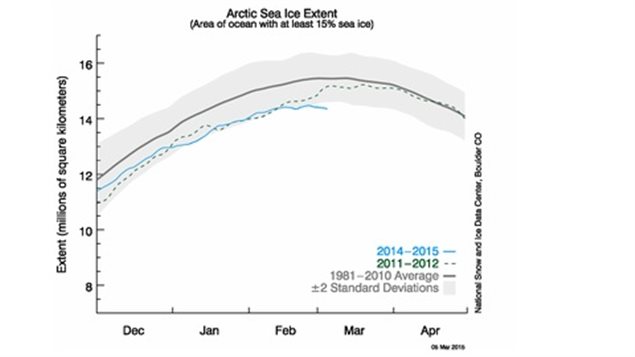
Previous years have seen a surge in Arctic ice extent during March (e.g., in 2012, 2014). However, the agency says that if the current pattern of below-average extent continues, Arctic sea ice extent may set a new lowest winter maximum this year.
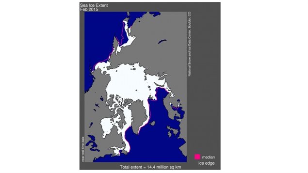
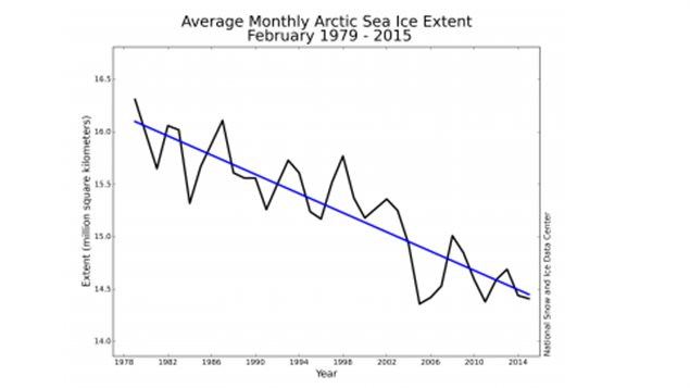
The NSIDC reports Arctic sea ice extent in February averaged 14.41 million square kilometers or the third lowest February ice extent in the satellite record.
While the ice cover this year is 50,000 square kilometers more than the lowest on record of 2005, it is still 940,000 sq/km below the 1981-2010 average for the period.
The NSIDC observations about this year’s winter Arctic sea ice extent are supported by Denmark’s Polar Portal, which also evaluates Arctic ice extent.
In the Antarctic there has been a trend of slightly increased ice extent.
Claire Parkinson of NASA recently presented the global average (Arctic plus Antarctic) trend in sea ice extent for the period 1979 to 2013. Overall, global sea ice has declined, despite the positive trend in Antarctic extent. The annual average trend is -35,000 square kilometers (-13,500 square miles) per year, or about -1.5% per decade
However, sea-ice extent is only a part of the picture. Many other studies have shown very substantial ice volume loss from the Antarctic, the Arctic, and the Greenland ice sheet.


For reasons beyond our control, and for an undetermined period of time, our comment section is now closed. However, our social networks remain open to your contributions.